Street 360 is an autonomous system for visual mapping. Visual mapping is the ability to connect between the digital map and the panoramic visual from the mapped area.

The system allows photographing and mapping of an area and then displays panoramic visuals of the area as an additional layer of the digital map.
In other words, when the user is looking at an area on the map, it’s possible, by simply pressing a button, to see the area from the point of view of a person standing on site. The system allows the user to view the area in all directions; left, right, up and down and to zoom in on specific objects or to zoom out for a wider view. Then the user can navigate to next/previous panorama and to “walk the street” as if he is there.
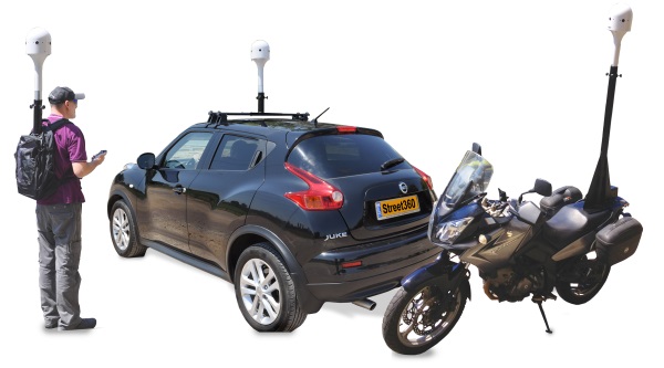
The Mapping System can be carried with a backpack or installed on car, cycles or motorcycle
How it Works
The Street 360 system includes three modules:
Camera and Mapping Module – The camera module consists of a number of high-resolution sensors that captures the area in 360 degrees, a GPS receiver and an orientation sensor. The unit is controlled and monitored using a computerized control system with specialized software. The camera module is small and light and can be carried on a back pack or installed on a vehicle. The operation is very simple and is fully automatic. The operator can travel or walk around in a normal fashion. During this process the system will automatically capture and save location and orientation info. So if, for example, we want to scan a specific neighborhood, all we need to do is to install the camera module on the roof of a vehicle, turn the system ON and drive through the streets.
Processing Module – After mapping the area, the information stored in the camera and mapping module is transferred to the processing module. The processing module is a computer server running specialized software. The software processes the raw pictures into panoramic pictures and adds map references taken from the GPS and orientation sensors. Every panoramic picture is tiled so that it is ready for a quick display. Next, the software creates a series of panoramic pictures on the surface of the digital map that match the original route. In this way, a visual map of the area grid is created.
Display Server – After all the material is processed, we need a viewing system capable of handling the enormous amount of information collected that will allow the user to view the processed, panoramic pictures. At the same time, the user will have the option of moving from one picture to another and can also zoom in to examine details as if they were walking around the actual area or street. This is accomplished by our server software that can manage and manipulate the huge amount of data gathered via the collection process and which also allows for a large number of users to access the system and view panoramic views whether from an organizational Intranet or the Internet according to the client's needs. The system also allows for the comparison of pictures taken at the same location on different dates.
The recorded tracks of the visual mapping is displayed on OpenSteetMap layer. We can display the tracks on your organization maps by opening a service in your GIS Server. Using Google Maps and satellite layer may require map license from Google.

Providing solutions for a variety of needs
Following are just few of the applications of the Street 360:
- Visual mapping of city streets for use by local authorities. Examples of possible uses include collection of signposting fees, monitoring construction irregularities, documentation of the city's long term appearance and changes, etc.
- Visual mapping of tourist sites for marketing purposes and long term documentation of the site.
- Visual mapping of archeological excavation sites before they are covered and buried for conservation purposes.
- Visual mapping of exhibitions in order to provide visitors a virtual tour of the exhibition.
- Visual mapping of large shopping centers for marketing purposes.
- Visual mapping of disaster areas such as earthquakes, tornados, storms, floods etc. in order to freeze the image of disasters after effects for analysis and conclusions with regard to preparations for similar disaster scenarios.
- Visual mapping of strategic buildings as part of the preparation of field portfolios and disaster evaluation.
Monitor changes over time

Street 360 on the news - I24 News
Download Street 360 brochure
English PDF
Spanish PDF
Street360 is a joint venture of GeoSpotX Ltd and HSS Ltd
